![FAA Part 107 Online Course vs In-Person: Which Actually Gets You Licensed? [2025 Guide]](https://images.squarespace-cdn.com/content/v1/566c4efe5a5668242bae4c95/1746299796360-WSXOD1QI8JKNBDU61T0Z/Part+107+Online+vs.+In-Person+Course+%281%29.jpg)
FAA Part 107 Online Course vs In-Person: Which Actually Gets You Licensed? [2025 Guide]
The Part 107 test gives you 120 minutes to answer 60 multiple-choice questions, and you need 70% to pass. The FAA Part 107 test boasts a 79.95% average pass rate, which might make you think the choice between online courses and classroom training doesn't matter. But this choice is really personal for each and every learner. Your learning style and career goals can make the most important difference in getting licensed and starting to earn money quickly or use your certificate as a way to advance an existing career in an industry that is adopting drone use.
Many online courses like Drone Launch Academy cost $199 and tend to be more budget-friendly than in-person courses, which run usually $500+. But classroom in-person training comes with unique advantages that pay for themselves after one or two drone service jobs (or that job promotion!)
Students who choose in-person training programs often achieve higher passing rates of up to 99%. The in-person programs also generally help complete beginners become licensed commercial drone pilots faster than self-paced online options, which is evident in this in-person Part 107class review: ‘’ I had been wanting to take the Part 107 exam for quite some time. I’ll be the first to admit I super suck at self-study. When I took the 107 exam, two weeks after the class, I felt prepared and apparently was. I passed with a 95%.”
You'll soon find the training method that matches your learning style and career goals best. This knowledge will help you choose between a flexible FAA Part 107 online course and a well-laid-out classroom environment.
What Is the FAA Part 107 Certification and Why Do You Need It?
The FAA Part 107 certification, also known as the Remote Pilot Certificate, gives you legal permission to fly drones for any non-recreational purpose. Since 2016, this certification has become the standard requirement for all commercial drone operations in the United States. You should know that "commercial" is a vital term—it goes beyond just getting paid.
The basics of commercial drone licensing
Money doesn't need to change hands to require you having Part 107 certification, which surprises many people. Taking drone photos of your house to sell it or providing imagery for your church counts as "commercial" or more accurately, "non-recreational". There are a few requirements in order to qualify to take Part 107 exam:
· You must be at least 16 years old
· You must be able to read, write, speak, and understand English
· You must be physically and mentally fit to operate a drone safely
Getting your certification requires passing the Unmanned Aircraft General - Small (UAG) Knowledge Test. This 60-question multiple-choice exam covers airspace regulations, weather conditions, and emergency procedures. You need to answer at least 42 questions correctly to achieve the passing score of 70%. The Part 107 test costs $175 at FAA-approved testing centers nationwide.
Why choose in-person Part 107 prep course over online drone training course.
Your learning style will affect your success rate when choosing between an FAA PART 107 online courses and classroom training. Online courses let you work at your own pace, while in-person training provides guided learning, direct answers and helps you understand complex aviation concepts better, especially if you need clarification of a concept broken down by an expert who you can ask questions face to face.
The classroom setting also creates accountability that helps prevent the common problem of procrastination in self-paced online options, which is common to stretch from a couple weeks course if you take it at your own pace a few hours a day, to months or even longer if you don’t have the discipline or time to dedicate at least a few hours a day to it.
Classroom training offers networking opportunities with potential clients and collaborators compared to online Part 107 study courses. Students often find their first paying jobs through connections made during in-person training. The higher cost of classroom instruction pays off quickly through faster licensing and earlier earning potential.
What happens if you fly commercially without a license
Flying without proper certification can lead to serious consequences. The FAA takes airspace safety very seriously and imposes penalties that should make anyone pause before operating commercially without proper credentials.
Flying without a license could result in civil penalties up to $27,500. Criminal penalties can reach $250,000 and/or imprisonment for up to three years. The FAA Reauthorization Act of 2024 has increased fines up to $75,000 per violation for drone operators who conduct unsafe or unauthorized operations.
The FAA can suspend or revoke your drone pilot certificates and might ban you from future flying. These aren't empty threats—local Flight Standards District Offices actively investigate reported violations.
Needless to say, if you are serious about enhancing your career and earnings by using a drone to provide and sell drone services, then you should be legal to fly it. Getting licensed is the logical choice in this case.
The financial upside of getting licensed quickly
A certified Part 107 drone pilot certification opens many profitable opportunities. Full-time salaried positions range from $35,000 to $200,000 annually in this growing industry, while starting your own drone services business or using your skills as a side gig can also be very lucrative. So, if you are interested in getting licensed quickly to get into this growing industry and start getting real experience to increase your pay rate over time, then getting licensed quickly is in your best interest.
Your Part 107 flying privileges last 24 months after you initially acquire the Part 107 certificate. After that, you'll need to complete a free online recurrent training course through the FAA. This keeps your knowledge updated with changing regulations and safety standards.
The drone industry grows faster each day, and the FAA steadily expands flying privileges for licensed pilots. Part 107 certification now lets you fly over people and vehicles under certain conditions—something recreational pilots can't do. You can request waivers for specialized operations, giving you flexibility recreational pilots don't have.
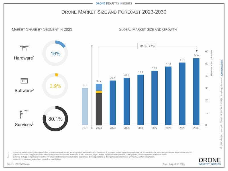
The path you choose—online course or classroom instruction—should match your timeline to start earning and your best learning environment. Getting your certification keeps you legally compliant and ready to take advantage of the expanding commercial drone market’s services sector, which is predicted to grow to $57.8B by 2030 with the largest share of the being drone services at 78% of that (or $45B).

Global Drone Market Size 2025-2030
Breaking Down the Part 107 Test: What You're Up Against
Taking the FAA Part 107 test without preparation is like playing chess when you only know checkers. Test-takers score 79.95% on average with an 84.2% overall pass rate. A good grasp of what you're up against will help you prepare better.
Test format and passing requirements
The "Unmanned Aircraft General - Small (UAG)", or Part 107 knowledge test, has 60 multiple-choice questions. You get 120 minutes to complete it. The passing score is 70%, which means you need 42 correct answers. Each test pulls questions randomly from a bigger question bank, so everyone gets a different version.
A successful test-taker warns, "Cramming two hours before the test is really not enough to pass". Based on what you already know and how you study, you should spend at least a weekend to learn the material well.
The choice between an FAA Part 107 online course and classroom training makes a big difference. Online courses let you control your study schedule—but we all know how easy it is to put things off. Many students end up rushing through the content just before exam day. Classroom settings give you a fixed schedule, structured learning time, and instructors who can clear your doubts right away.
The 5 knowledge areas you must master
The FAA spreads five main topics across the test:
1. Regulations (15-25% of questions) - Rules for drone operations under Part 107
2. Operations (13-18% of questions) - Best practices and procedures
3. Weather (11-16% of questions) - Weather patterns and their effect on drones
4. Airspace classification (8-15% of questions) - Rules, limits, and chart reading
5. Loading and performance (7-11% of questions) - Weight limits and drone capabilities
Most first-timers find sectional charts and airspace classifications the toughest parts: “I tried an online course and got lost at the aviation chart section. After researching “in person” classes I decided to go with V1DroneMedia’s course. The instructor was extremely knowledgeable and his teaching method stuck. I am happy to announce I passed my Part 107 exam just this afternoon with an 85%. Something that seemed so difficult to achieve yet actually happened.” Understanding such challenging topics works better with in-person teaching where you can ask questions and get help—something you can't do with online videos. See an example of an aviation sectional chart below and try to make sense of it without someone walking you through it!

Example of an aviation sectional chart you have to learn to read and answer questions on for the FAA Part 107 Drone Pilot Exam
The FAA states, "Unless you have been flying drones for some time or have previously taken the knowledge test, you will need to spend time studying for the exam”. Aviation knowledge isn't something most people use daily, so you face a steep learning curve.
You have a choice: study these complex topics by yourself through a part 107 online course, or learn from an instructor who can explain things clearly and answer your questions?
Classroom training works great for visual and hands-on learners trying to master these topics. Online courses might cost less upfront, but classroom training often leads to better pass rates on the first try. This helps you avoid the $175 retest fee and get your 107 drone license quicker.

V1DroneMedia’s instructor explains an aviation sectional chart during FAA Part 107 Exam Prep Course
Remember this: getting licensed faster means earning money sooner. Even if you pay $300-500 more for an in-person course, a couple of drone jobs will cover that cost. Plus, your classmates might become your support group or partners—something you won't get studying alone online.
The part 107 test isn't impossible, but you need solid preparation. Your learning style and career plans should guide you to pick the training method that works best for you.
Online Part 107 Courses: The Self-Paced Option
Looking for an FAA part 107 online course feels like stepping into a buffet with countless choices. The digital world has options that fit any budget, from basic subscriptions to deluxe packages. Your choice buys more than just knowledge - it's about finding a learning style that clicks with you.
Top online courses and their price points
Online Part 107 course prices range widely. USI's flexible plan starts at just $10 per month for subscriptions. Most respected providers charge $125-$250 for unlimited access. Top-tier options like Drone Pilot Ground School cost $299 for their detailed packages. These online choices cost less than classroom alternatives - but that price gap needs a closer look.
These online courses come with money-back guarantees - evidence of their quality and recognition that self-study isn't right for everyone. The fine print matters though. Most refunds require you to finish the course and fail your exam.
What you actually get for your money
Each price point offers different value. Most online courses include:
· Video lessons (typically 80+ videos across all knowledge areas)
· Practice exams with 300-400 questions from real FAA tests
· Study guides or "cram sheets" for last-minute review
· Unlimited access to materials for future reference
Premium packages stand out with weekly live Q&A webinars, mobile apps, and direct instructor help. Some courses add flight skills training - valuable if you are looking for hands-on training, since the Part 107 exam doesn't test your flying abilities.
These courses now feature custom study plans to guide your learning. Whatever provider you pick, self-paced learning lets you study when time allows. This works great with family duties or odd work hours.
The real completion timeline (not what they advertise)
Marketing claims often stretch the truth. Many online drone training courses promise quick licensing "in just a few weeks", but success depends on your dedication and background knowledge.
Drone courses need 15-20 hours to complete. Some providers claim 10 hours is enough. Most students work full-time, so finishing usually takes 2-3 weeks of steady study.
Self-paced learning brings freedom but also challenges. Students often rush their studies right before test day without classroom deadlines pushing them forward.
This raises a key question: Do you finish online courses once started? A classroom setting might work better if you have unused exercise equipment at home. While online courses cost less upfront, landing one or two paid drone jobs could cover in-person training costs. Getting market-ready faster might save money and study scheduling conflicts long-term.
In-Person Part 107 Training: The Guided Experience
A classroom environment for Part 107 training creates a unique experience compared to late-night laptop studying. Students find themselves surrounded by fellow future drone pilots who could become their partners or collaborators.
Available classroom options across the country
Drone enthusiasts can choose from several in-person training providers. Companies like DARTdrones and Dronegenuity run classroom-based Part 107 study courses in major U.S. cities, while V1DroneMedia services the Midwest and Northeastern states in Cleveland, Ohio. All of these providers keep class sizes small (10-15 students) to maximize individual attention.
Most training providers release their schedules about 3 months ahead, and popular spots disappear quickly due to limited in-person class availability. Some companies even blend online pre-work with in-person teaching to create hybrid solutions that give students dual benefits.
Typical course structure and duration
Most classes complete Part 107 test prep in a single or couple of full 8-hour days, from 8:30 a.m. to 5:00 p.m. with breaks for lunch. This focused approach helps students finish their classroom training much faster than online learners who often take weeks. However there is a lot of information covered in that 1 or 2 days courses, so you have to choose the best structure for you.
The curriculum covers essential topics:
· Drone regulations and FAA rules
· Airspace classifications and sectional charts
· Weather and micrometeorology
· Flight operations and emergency procedures
· Loading and performance calculations
Students get detailed guided breakdown of complex topics like sectional charts or airspace restrictions. Many courses also include practical drone operations instruction - something online videos can't match.
The true cost breakdown
The numbers tell an interesting story. The FAA knowledge test costs $175 at testing centers nationwide. In-person courses range from $545 (V1DroneMedia’s)-$1500 (DARTdrones), while online options average $200-$300. This price difference often pushes pilots toward online training initially.
The extra investment brings valuable returns. Quick material comprehension and networking with future commercial pilots make the cost worthwhile. A couple of paid drone jobs can offset the additional expense - jobs that could even come from classroom connections.
There are other factors to consider. For example, Dronegenuity's package combines online prep materials with in-person training. Students can also benefit from group rates, military/first responder discounts, and packages that include test fees. Whereas V1DroneMedia’s course is taught by a commercial airline pilot with decades of professional aviation experience in US national airspace, who also runs his own drone services business, thus offering real world drone operations expertise to their students.
Classroom training motivates students to schedule their FAA Part 107 exam within days of completion, unlike online courses where procrastination can delay licensing. The structured setting helps students overcome common self-paced learning challenges.
Hands-on learners and those who struggled with online courses benefit from classroom accountability and structure. Success rates increase when students match their learning style to the training format.
The classroom environment proves invaluable for students who learn through discussion and demonstration. Direct access to expert instructors and the fastest way to pass Part 107 creates benefits beyond test day.
The Learning Experience: How Your Brain Actually Processes This Stuff
Your brain works differently than a computer storing drone information—it processes knowledge based on your personal learning style. Studies show that your choice of Part 107 study method affects not just passing the test, but how soon you can start making money from your certification.
Visual learners vs. hands-on learners
People learn differently. Video demonstrations and online tutorials work great for visual learners, who find charts and diagrams help them grasp complex ideas. However, students who prefer hands-on learning often find digital-only instruction challenging and need physical practice with direct guidance to understand concepts.
"The supervision of an expert instructor ensures that students get their questions answered immediately, and don't end up developing bad habits that they will need to unlearn later on," notes Jason Damman, V1DroneMedia’s Part 107 instructor. This becomes vital when learning essential skills like reading sectional charts or interpreting weather data—areas where many test-takers struggle.
Here's something to think about: hands-on drone training lets you practice proper responses with expert guidance—something you can't get through a screen. Online courses give busy professionals the flexibility they need, with round-the-clock access to materials and online communities.
The accountability factor: finishing what you start
Let's face it: online courses have terrible completion rates. Procrastination becomes your worst enemy without scheduled sessions and face-to-face accountability.
Students taking faa part 107 online courses need at least 15-20 hours of studying for the test. This might seem manageable until you try carving out time between work, family, and daily life. Classroom settings create built-in accountability—you've invested more money and committed to specific dates.

Online Part 107 Prep Students can face many distractions throughout learning process
The structure of in-person training mirrors real-life drone operation, where planning and preparation are essential. This well-laid-out approach helps students get licensed and start billing clients faster.
Retention rates: what you'll remember on test day
Studying means little if you can't remember the information when it counts. Different learning methods produce vastly different retention rates. This isn't just about memorizing facts—you need to understand aviation concepts well enough to use them.
Flashcards and simple knowledge questions might work for basic concepts. But the challenging sections—making up over 50% of the test—need an instructor who can explain ideas different ways until you understand them completely.
The fastest way to pass Part 107 matches your learning style perfectly. Self-disciplined visual learners might do well with online courses. Hands-on learners who need structure find classroom training more effective and economical—because getting licensed faster means earning money sooner. Those first couple of drone jobs don't just cover extra training costs; they launch your business or career while online learners might still puzzle over sectional charts.
Time-to-License Comparison: Which Gets You Flying Faster?
Your drone income clock starts ticking as soon as you decide to get licensed. The difference between successful commercial pilots and hobbyists often boils down to how fast they turn their knowledge into cash flow. Your choice between self-paced online study or classroom training will shape how quickly you become a legal commercial drone operator.
Average study hours required for each method
The numbers show that proper Part 107 test prep needs serious dedication. The FAA suggests 20 hours of study time to pass the Part 107 exam. Most online courses pack about 15 hours of lessons spread across 200+ videos. These courses also include more than 300 practice questions to get you ready for test day.
Some online courses promote their "14-day challenge" - claiming you can become a commercial drone pilot by studying just 1 hour daily for two weeks. The truth is, these quick schedules work for very few people. Most students who learn online spend 15-20 hours total preparing for the test.
Classroom training changes everything. These courses pack the same material into full 8-hour days with practice tests in between, and wrap up the whole curriculum in just 1-2 days. Students usually take their tests right after finishing the course, and usually have access to study materials and extra practice tests to gain more confidence if they feel they need it.
Scheduling realities and procrastination factors
Here's what online course ads don't tell you: procrastination kills drone careers quietly. Research shows that over 50% of students regularly put off their academic work.
Students taking an FAA part 107 online course battle their own habits. Without a fixed schedule, many future pilots keep pushing their lessons to "tomorrow." Classroom settings create built-in accountability - you've paid more money upfront and committed to specific dates.
One expert in the field says, "With an in-person class, all the information hits you at once and you can't set your own pace". This limitation actually helps because it makes you focus and learn the material quickly instead of putting off your studies.
From first lesson to passing the test: realistic timelines
Here's how long it takes to go from deciding to get licensed to flying commercially:
Online learners typically need:
· 2-3 weeks (or more) to finish course materials.
· 1-2 weeks to schedule and take the FAA exam
· 10 business days to get their temporary certificate
· 6-8 weeks to receive their permanent certificate
Classroom learners need:
· 1-2 days to complete intensive training
· 3-7 days to schedule and take the FAA exam
· Same certificate processing times
The big difference? Online students stretch their 15-20 study hours over weeks or months. Classroom students finish in days. Those extra weeks mean lost income potential.
Here's a practical way to look at it: classroom training might cost $300-500 more than online options, but one or two paid drone jobs could make up that difference. Getting your license three weeks earlier could mean booking your first commercial flight while online students still work through practice questions.
Online courses work well for some people. Self-paced learning offers flexibility that classrooms can't match if you're highly self-disciplined or have an unusual schedule. Still, most aspiring commercial pilots who want to start making money with their drones find that classroom training's structured environment and faster completion time make it the quickest way to pass Part 107. Here is another student’s experience described in a Google Review: “I needed to get my Part 107 Certification for work and scheduled my exam in advance of studying to motivate me. I wasn’t having as much luck self-studying online this completely new material and decided an in-person class would suit me better. Long story short, I flew from Texas to Ohio, on a whim, to take this [Part 107 Prep] class over the weekend. It was an amazing class and quelled so much of my anxiety around taking this test. And I passed! In 3 days, I became certified from his teachings.”
The Hidden Benefits of Classroom Training
Classroom training delivers major benefits beyond learning the basics. These hidden advantages make the real difference between passing a test and starting a thriving drone business.
Networking with future clients and collaborators
A classroom filled with aspiring drone pilots becomes your first professional network. Many training providers help students land their first paying jobs. Your classmates could become business partners, referral sources, and even clients. This personal connection doesn't happen through a computer screen.
Direct access to expert knowledge
A classroom setting lets you ask questions right away when complex topics like airspace restrictions confuse you. Online videos can't give you tailored explanations.
The instructors aren't just teachers - they run their own drone businesses and have backgrounds as aircraft pilots. Their knowledge helps students succeed.
The motivation of learning among others
People often quit online courses halfway through. Learning face-to-face creates natural accountability. The classroom environment creates healthy competition and support. Seeing others master difficult concepts pushes everyone to improve. The cost difference between online and in-person training pays off quickly - just one or two paid drone jobs cover the extra investment within weeks of certification.
Making the Financial Case: Is the Extra Cost Worth It?
The math tells the story between online and in-person drone training. Your investment versus returns needs more than just price comparison.
How drone jobs quickly cover your training investment
The real numbers paint a clear picture. Freelance drone pilots earn between $25-$200 per hour. One or two gigs can easily make up the cost difference between online and classroom training. Most companies see returns on their drone investment within 2-3 projects. This makes the original price gap seem much smaller afterward.
Full-time drone pilots earn average salaries from $60,000 to $200,000 annually. Getting your license a few weeks faster through classroom training could mean thousands more in your pocket.

Drone Pilot Salary Ranges by Specialty
The cost of failing and retaking the test
The numbers get interesting here. A failed Part 107 test means paying another $175 to try again. You'll need to wait 14 days before the next attempt. Those two weeks could have been spent earning money instead of studying more.
Some online courses will pay back your test fee if you fail after scoring 85% on their practice exams. Classroom training students tend to pass on their first try, which makes retake fees less common.
Hands-on learners find classroom training a smart investment. The benefits show through faster licensing, better knowledge retention, and valuable industry connections.
Conclusion
The choice between online and classroom Part 107 training depends on your learning style. Students who are self-disciplined and excel with digital content might find online courses worth $199-299. But classroom training's $500+ price tag proves to be a smart investment for most aspiring pilots.
Classroom students usually finish their training and take the test within 1-2 weeks. Online learners tend to spread their studies over 2-3 months. This faster timeline means you'll start earning sooner, which makes the extra cost minimal. A couple of drone service jobs will easily cover the difference in training costs.
Your learning style should guide your decision more than your budget. Students who learn by doing pick up complex topics like sectional charts and airspace rules much faster with an instructor's guidance. The classroom environment creates accountability that keeps you on track. The in-person Part 107 Prep Course gives you expert instruction, networking opportunities and the quickest path to your commercial drone license.
Each week spent studying alone means lost potential income. Classroom training costs more upfront, but getting licensed faster and connecting with future collaborators makes it worthwhile for most pilots. Success in the drone industry goes beyond passing a test - it's about building relationships and launching your business quickly.
FAQs
Q1. How long does it typically take to prepare for the FAA Part 107 exam? Most people spend 15-20 hours studying for the Part 107 test. Online courses usually take 2-3 weeks to complete if you consistently dedicate a few hours a day to studying, while in-person training can be finished in 1-2 intensive days, such as V1DroneMedia’s FAA Part 107 2-day in-person course.
Q2. What are the main differences between online and in-person Part 107 training? Online courses offer flexibility and lower costs, typically around $200-$300. In-person training costs $545-1500 but provides hands-on instruction, networking opportunities, and often results in faster completion and higher pass rates.
Q3. What topics are covered on the Part 107 exam? The exam covers five main areas: regulations, operations, weather, airspace classification, and loading/performance. Questions on airspace and sectional charts are often considered the most challenging for test-takers.
Q4. How much can I expect to earn as a licensed drone pilot? Entry-level drone pilots can earn around $35,000-42,00 annually, while experienced pilots (5+ years) can command $88,000 or more. Freelance rates range from $25 to $200 per hour depending on the job and experience level.
Q5. What happens if I fail the Part 107 exam? If you fail the exam, you'll need to wait 14 days before retaking it and pay another $175 fee. Some online courses offer to reimburse your test fee if you fail after scoring well on their practice exams, while in-person training often results in higher first-time pass rates.

Better Cost Estimates and Site Understanding Through Drone Technology: Your Construction RFP Guide
Ready to take the guesswork out of your construction project estimates? The right cost estimates make all the difference between project success and budget overruns. Modern drone technology delivers precise site analysis at a fraction of traditional surveying costs and time, giving you accuracy that manual methods simply can't achieve in the same amount of time.
Drone-powered photogrammetry gives project managers a clear view of construction sites from every angle - especially valuable for expansive projects where ground surveys fall short. Your team spots potential issues before they become problems, tracks daily progress, and makes smart decisions that keep projects on schedule. The added benefit? Drone surveys handle dangerous terrain safely, eliminating the risks tied to manual site inspections.
This practical guide shows you exactly how drone technology creates spot-on cost estimates for your construction RFPs. We'll walk you through smart ways to include drone data in your documentation, break down the real cost advantages, and share proven techniques to get the most value from your investment.
Incorporating Drone Data into RFP Documentation
Looking for crystal-clear RFP documentation? Drone technology delivers exactly that through GPS-referenced data collection and visual insights. That means better accuracy while significantly cutting documentation time.
Creating compelling visual presentations
Picture-perfect aerial photography and video captures every site detail, can give you professional 3D models and detailed topographic maps. Your RFP will stand out with stunning imagery, site maps that you can utilize for 3D renderings, helping give stakeholders a clearer picture of the finished project.
Demonstrating project understanding through aerial imagery
Expert aerial surveys can uncover the full story of your site - from elevation changes to drainage patterns and vegetation details.
Underground utility mapping and overlay techniques
Smart GPS drones follow carefully planned flight paths, taking hundreds of overlapping photos to build complete site models by utilizing drone photogrammetry. These models can pinpoint underground utility locations by working seamlessly with existing utility location data to deliver spot-on utility mapping reports.
Supporting cost estimates with precise measurements
Want measurements you can trust? Drone surveying delivers exceptional precision for volume calculations and material quantities. You can get:
· Volume measurements in minutes instead of hours
· Precision down to 1/10ft (3cm) for stockpile measurements
· Instant site condition updates through real-time data
This level of accuracy keeps your bids right on target, helping you stay competitive while protecting your profit margins.
Cost-Benefit Analysis of Drone Implementation
Ready to see the real financial impact of drone technology? The numbers tell a compelling story. Today's construction industry spends USD 8.00 trillion yearly, yet typical projects still run over budget and behind schedule.
Time savings in bid preparation
Think weeks of survey work - now done in hours. A 12-acre property survey shrinks from 100 hours to just 2 hours. Your team prepares bids faster, tracks progress more often, and handles more projects. The result? More contracts won and fewer project delays.
Using Drones Beyond RFP
Looking for precision in project tracking? Today's construction demands exact documentation at every stage. Drone technology captures crystal-clear aerial imagery, giving project managers unmatched site monitoring capabilities.
Maximizing ROI Through Strategic Drone Use
Want to see real returns on your drone investment? Smart implementation delivers exceptional results. Just ask Grade Tech - they employ the latest software that interfaces with our positioning tools to perform topographic and layout operations, advanced modeling programs, and modern job-tracking software to ensure efficiency at every stage of the project, cutting traditional survey times by 60-70%.
Project monitoring brings even bigger rewards, with drone use eliminating costly downtime.
Measuring and tracking cost savings
The proof is in the numbers - 92% of construction firms see positive ROI within their first year using drones. Your savings grow through reduced labor costs, minimal downtime, and precise measurements. The key to measuring drone use ROI? Careful tracking of every dollar saved across your project timeline helps fine-tune your drone strategy based on real results.
Construction Progress Monitoring for Project Management
Smart drone flights follow carefully planned routes, delivering consistent site documentation. Your project managers receive a focused package - 3-5 key images plus a 30-second video clip from each monitoring session. These visual updates spotlight potential delays or issues before they impact your timeline. Our clients catch inefficiencies early and adjust their strategies with confidence. Having an ongoing drone site capture schedule gives project manager and superintendent opportunity to request additional shots or data collection before a visit as needed for faster decision-making.
Client Project Updates with Drone Photos and Videos
Keep your stakeholders in the loop without site visits. Professional progress reports flow on a regular schedule, giving everyone clear insight into project developments. These detailed updates prove timeline adherence and milestone achievements to clients, and are especially helpful when clients are located out of state, or even out of the country (as was the case with one of our client projects).
Project Documentation for Marketing
Stunning aerial photography tells your project's story, highlighting its true scale and sophistication. Our clients use drone footage to:
· Build impressive time-lapse videos showing project progress
· Showcase sweeping panoramic views of projects for digital marketing
· Create winning portfolios for future proposals
The real power of drone technology lies in its versatility throughout your project's lifecycle. Your team can even upload raw footage directly to specialized construction software platforms, building a complete visual record of construction progress. Learn more about this topic in our Drone Use in Construction Marketing blog post.
Conclusion
Ready to take your construction RFP process to the next level? Drone technology delivers perfect cost estimates through exact measurements and detailed site analysis. Your team gains 90% better accuracy while slashing documentation time in half. Most companies see remarkable results in yearly savings and productivity gains over time, making drone technology a game-changer for modern construction management.
The path to success starts with committing to giving drone technology a try from the pre-construction RFP submission all the way to the completion of the project. The numbers will tell a clear story - while ongoing costs can average $5000-$20000 with consistent use of drone technology throughout construction project span (6-18 months usually), construction firms see positive returns within twelve months. Your tangible and intangible savings can grow quickly through streamlined costs, faster bid preparation, precise project monitoring, informed decision-making, improved client communication, and stunning marketing materials.
Want to see these benefits firsthand? V1Dronemedia offers a free drone photography and video shoot for your next RFP submission. Our expert team can also help you obtain accurate site measurement and mapping for better site visualization. Contact us to learn how you get your free drone shoot at the RFP stage!
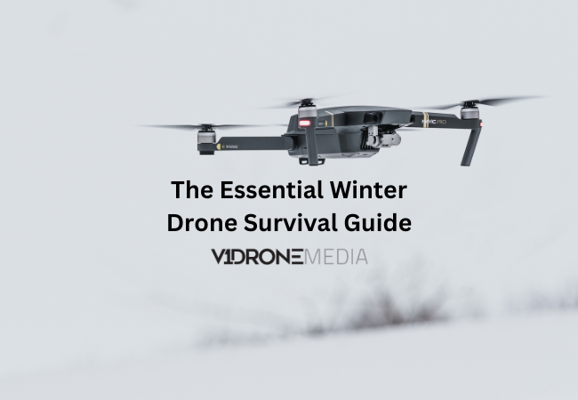
From Novice to Pro: The Essential Winter Drone Survival Guide
Operating drones in winter presents several challenges, many of which users commonly complain about. These issues can significantly impact both recreational and commercial drone operations during cold or hazardous weather conditions. Here are some of the most frequent issues that drone pilots encounter during winter months:
1. Battery Performance
Complaints: Batteries drain faster in cold weather due to reduced chemical reactions in lithium-ion cells. This is particularly noticeable when temperatures drop below freezing, as the chemical processes that generate electricity become significantly slower.
Impact: Reduced flight time and the need to carry extra batteries or cut missions short. Some pilots report flight times being reduced by up to 50% in extremely cold conditions, which can severely impact planned operations.
Suggestion: Ensure batteries are at room temperature before operation (at minimum 60-65°F or room temperature). Consider using battery warmers or insulated cases during transport. Once flying, the battery will generate some heat on its own, but you should expect shorter flight time. Carry extra charged batteries to counter this issue, and always monitor battery levels more frequently than in normal conditions. Read more about Maximizing Drone Battery Life regardless of weather conditions.
2. Ice and Snow Accumulation
Dangers of Icing in Winter Drone Operations YouTube Video on V1Dronemedia YouTube channel - click to watch!
Complaints: Snow or ice can accumulate on propellers, sensors, and the camera, affecting flight stability and image quality. This accumulation can happen rapidly, especially in wet snow conditions.
Impact: Icing buildup on the propellers, making them less efficient or destroying lift altogether, leading degraded performance or potential crashes. Even small amounts of ice can significantly affect aerodynamics and control.
Suggestion: Do not fly your drone during significant snow or during icing conditions. Drones do not have de-icing solutions like some airplanes do, so you risk losing your drone if you choose to fly it. If you must fly in light snow, regularly inspect the drone for any ice buildup.

My drone propeller with icing accumulation
3. Signal Interference
Complaints: Cold temperatures and atmospheric conditions, like snowstorms, can interfere with GPS and remote-control signals. Winter weather patterns often bring increased electromagnetic interference.
Impact: Loss of control or poor GPS lock, leading to unstable flights or difficulty with automated features. This can result in erratic behavior or complete loss of drone control.
Suggestion: As mentioned before, don't fly your drone during significant snow or during icing conditions. Certainly, do not fly in snowstorms or a hurricane, as you risk losing your drone. When possible, maintain a closer operating distance and ensure clear line of sight.
4. Condensation Issues
Complaints: Transitioning between cold outdoor temperatures and warm indoor spaces can cause condensation on the drone's electronics or camera lens. This is particularly problematic when moving quickly between temperature extremes.
Impact: Potential damage to internal components or blurred footage. Moisture can lead to short circuits and corrosion over time.
Suggestion: This is a common issue for any equipment with a camera, and it isn't something that is avoidable or fixable. Just something you should be aware of, and that it can interfere with getting good quality footage or imagery. Allow gradual temperature transitions when possible.
5. Reduced Visibility
Complaints: Fog, snow, and shorter daylight hours reduce visibility, making it harder to navigate or capture clear images. Winter conditions often create challenging lighting situations.
Impact: Safety concerns and lower-quality footage. Reduced visibility can make it difficult to maintain visual line of sight, which is required by regulations.
Suggestion: Don't fly in poor visibility conditions. Your footage quality will be poor, and you risk losing your drone. Plan flights during optimal daylight hours and monitor weather forecasts carefully.
6. Cold-Induced Fragility
Complaints: Plastic and other materials on drones may become brittle in low temperatures, increasing the risk of cracking or breaking on impact. This affects both the drone body and accessories.
Impact: Shortened lifespan of parts or the need for repairs. Even minor impacts that wouldn't normally cause damage can result in breaks during cold weather.
Solution: Minimize the time exposure of your drone to the cold. Store the drone in insulated cases when not in use and consider using additional protective gear during flights.
7. Pilot Comfort
Complaints: Operating a remote controller with gloves is cumbersome and presents significant challenges for drone pilots in cold weather. Traditional winter gloves are often too thick for precise control inputs, while removing them exposes hands to harsh temperatures. This creates an uncomfortable dilemma where pilots must choose between warmth and control accuracy. Even thin gloves can interfere with touch-sensitive controls and buttons, making smooth operation difficult.
Impact: The reduced dexterity and sensation when wearing gloves can lead to imprecise control inputs, potentially affecting flight safety and camera operations. Cold hands can cause trembling and reduced finger mobility, making it challenging to execute delicate maneuvers. These issues often force pilots to cut their flying sessions short, limiting productive flight time and potentially compromising planned operations or photography sessions.
Suggestion: Through personal experimentation, I've found several solutions to this common challenge. The most effective option has been investing in a specialized remote control "glove" or "mitten" designed specifically for drone controllers, similar to this listing on Amazon. Additionally, I sometimes opt to operate from inside my vehicle when conditions are particularly harsh, though this approach may not suit everyone's comfort level or flying style. The key is to experiment with different solutions until you find what works best for your specific needs and flying conditions.
9. Wind Challenges
Complaints: Winter often brings strong and unpredictable winds, making drones harder to stabilize. These gusty conditions can be particularly challenging in open areas or near buildings where wind tunnels form. The cold air density also affects drone performance differently than warmer conditions, requiring more power for the same maneuvers and potentially reducing flight time.
Impact: Higher risk of crashes and less smooth footage becomes a significant concern during winter operations. Wind gusts can suddenly push drones off course, making precise positioning difficult and potentially leading to collisions with obstacles. Camera stability is notably compromised, resulting in shaky footage that may be unusable for professional work. Battery performance can also degrade faster when fighting against strong winds, shortening already reduced flight times in cold conditions.
Suggestion: Winds affect different drones differently. It depends on the size, weight, and overall structure of the drone. Larger, heavier drones typically handle wind better than lighter models, but they consume more power in challenging conditions. Best practice would be to follow manufacturers' guidelines, of course! It should be noted in the user manual of the drone. Most manufacturers provide specific wind speed limitations and recommended operating conditions for optimal performance and safety.
Some drone enthusiasts and professionals adapt to harsher conditions by using specialized gear (waterproof drones are not on my list because they are not practical or affordable for the majority of drone operators), or by limiting their operations to milder weather days. I opt for the latter, as it provides the safest approach while preserving equipment longevity.
Overall, drone operations depend on the weather conditions, and since they are even more challenging in the areas that get snow and icy conditions in the winter, I fly my drone much less in the winter and in the rainy spring and fall seasons since I am located in the Midwest (Cleveland, Ohio). The combination of wind, precipitation, and cold temperatures creates a particularly challenging environment that requires careful consideration of safety and equipment limitations.
I hope you find this blog post useful. As usual, reach out to me with any questions, comment below, join our drone training newsletter for drone training class updates, new blog posts or YouTube video notifications.

Police Drone Training: Key Skills and Certification Requirements
The rise of drone technology has sparked a revolution in law enforcement, leading to an increased demand in drone pilots at law enforcement agencies across the United States. Police departments all over the United States, including Ohio, New York, Michigan and Pennsylvania are integrating unmanned aerial systems (UAS) into their operations. This shift has created a need for comprehensive training programs that equip officers with the skills to operate drones effectively and safely in various scenarios, including crash scene reconstruction, search and rescue missions, and evidence collection.
Police drone operator training goes beyond basic flight skills. It encompasses a wide range of competencies, from mastering standard flight maneuvers and aerial imagery to understanding specialized applications like aerial photogrammetry an even thermal imaging. This article delves into the key skills and certification requirements for police drone pilots, exploring the essential components of UAS training courses. It also examines how different states approach law enforcement drone training and the specific applications that make drones invaluable tools for modern policing.
FAA Certification Requirements for Police Drone Pilots
The Federal Aviation Administration (FAA) has established specific to ensure safe and legal operations. These requirements are crucial for law enforcement agencies integrating unmanned aerial systems (UAS) into their operations.
Part 107 Remote Pilot License
The foundation of police drone training is obtaining a Part 107 Remote Pilot License. This certification applies to drones weighing used for commercial purposes, including law enforcement activities. To obtain this license, police officers must meet several criteria:
1. Be able to read, speak, write, and understand English
2. Be in a physical and mental condition to safely operate a drone
3. Pass the initial aeronautical knowledge exam, known as the "Unmanned Aircraft General – Small (UAG)" test, also known as Part 107 Test.
The Part 107 certification allows police drone operators to fly their UAS at daylight or at twilight and nighttime hours with anti-collision lighting. However, they must always yield the right of way to manned aircraft and obtain permission to fly in controlled airspace 400 feet within their line of sight
Studying for the FAA Part 107 Exam
Preparing for the Part 107 exam is a crucial step in police drone training. The exam covers a wide range of topics, including:
1. Applicable regulations for small UAS operations
2. Airspace classification and operating requirements
3. Aviation weather sources and effects on small UAS performance
4. Small UAS loading and performance
5. Emergency procedures
6. Crew resource management
7. Radio communication procedures
8. Determining the performance of small UAS
9. Physiological effects of drugs and alcohol
10. Aeronautical decision-making and judgment
11. Airport operations
12. Maintenance and preflight inspection procedures
Many police departments allocate between 15 to 20 hours of study time for officers to prepare for the test. Various resources are available, including online test prep courses and free materials provided by the FAA. It's essential for police drone training programs to incorporate comprehensive study materials and practice tests to ensure officers are well-prepared for the exam. If you are a police officer looking to get your Part 107 drone pilot license, you can take our regularly scheduled 2-day in person Part 107 Prep class in the Cleveland, Ohio, area, and take the exam to get your Part 107 certificate shortly thereafter. If you are a police department that is looking for multiple officer Part 107 training, along with flight experience training, explore our drone training options for law enforcement, which we can bring directly to your department.
Practical Flight Experience
While the FAA does not mandate a specific number of flight hours for certification, practical flight experience is crucial for police drone operators. Law enforcement agencies often incorporate hands-on training into their UAS programs to ensure officers can effectively operate drones in various scenarios.
Key aspects of practical flight training for police drone operators include:
· Mastering basic flight controls and maneuvers
· Understanding drone capabilities and limitations
· Practicing emergency procedures
· Conducting simulated missions relevant to law enforcement, such as search and rescue or crash scene reconstruction
· Familiarizing officers with specific drone models used by their department
· Practicing a variety of flight scenarios to get more familiar with the controls
It's worth noting that an individual can obtain an FAA Remote Pilot Certificate without ever having flown a drone. However, for police drone training programs, incorporating practical flight experience is essential to develop competent and confident operators. There is a variety of ways to assess the competency of police drone pilots which can be built-in to police drone training programs.
To maintain their certification, police drone pilots must complete an online recurrent training course every 24 calendar months. This ongoing training helps ensure that officers stay up-to-date with the latest regulations and best practices in UAS operations.
By adhering to these FAA certification requirements and incorporating comprehensive training programs, law enforcement agencies can develop skilled and compliant drone operators, enhancing their capabilities in various police operations.
Essential Flight Skills for Law Enforcement UAS Operations
Law enforcement agencies integrating unmanned aerial systems (UAS) into their operations require officers to develop a specific set of skills to operate drones effectively and safely. These skills are crucial for various applications, including traffic collision reconstruction, and aerial surveillance, and search and rescue missions.
Basic Maneuvers and Controls
Mastering is fundamental for police drone operators. This includes the ability to perform precise takeoffs and landings, maintain stable hovering, and execute controlled movements in various directions. The is an entry-level test method designed to assess these essential skills. It requires remote pilots to conduct climb to specified altitudes of 10 and 20 feet above ground level, perform yawing turns, and execute forward, reverse, and transverse flight maneuvers.
Accurate control and maneuverability of the UAS are critical for ensuring the safety of both the drone and individuals on the ground. Pilots must develop a solid understanding of their drone's capabilities and limitations, allowing them to fly smoothly and confidently in various scenarios and conditions.
Advanced Flight Techniques
As officers become more proficient, they must master advanced flight techniques to handle complex law enforcement operations. This includes skills such as:
· Aerial search tactics: Pilots should be adept at conducting efficient search patterns when looking for missing persons or suspects.
· Night operations: Operating drones in low-light conditions requires specialized skills and knowledge of thermal imaging technology.
· Precision flying: The ability to navigate through tight spaces and around obstacles is crucial for applications like building inspections or tactical operations.
· Data collection: Officers must be proficient in using various payloads, such as to gather crucial information during missions using high-resolution cameras and thermal sensors
· Learn to operate FPV drones that allow law enforcement survey and clear indoors areas without putting police officers in the line of fire
Advanced training should also cover mission planning, deployment preparations, and the use of specialized equipment like thermography.
Emergency Procedures
Preparing for and responding to emergencies is a critical aspect of police drone training. Officers must be well-versed in handling various scenarios that may arise during UAS operations. Some key emergency procedures include:
· Loss of signal: Pilots should know how to activate the Return-to-Home (RTH) function and maintain visual line of sight with the drone.
· Low battery situations: Understanding how to monitor battery levels and execute safe landings when power is running low is essential.
· Adverse weather conditions: Officers must be prepared to adjust flight plans or execute emergency landings in case of sudden changes in weather.
· GPS signal loss: Pilots should be able to switch to manual mode and safely land the drone when GPS navigation is compromised.
· Obstacle avoidance system failure: Knowing how to manually navigate around obstacles and prioritize safe landings is crucial.
Regular practice of simulated emergency scenarios in controlled environments can help build confidence and improve response times.
By focusing on these essential flight skills, law enforcement agencies can ensure their drone operators are well-prepared to handle the challenges of UAS operations in various policing scenarios. Continuous training and assessment using standardized methods like the NIST sUAS Test Methods can help agencies maintain high levels of proficiency and readiness among their drone pilots.
Specialized Police Drone Applications and Training
Drones have evolved to encompass a wide range of specialized applications, equipping officers with the skills to leverage unmanned aerial systems (UAS) in various law enforcement scenarios. These specialized applications require tailored training to ensure officers can effectively utilize drones in critical situations.
Crime Scene Documentation
One of the most significant advancements in law enforcement drone use is in crime scene documentation. Drones have revolutionized how police capture and preserve evidence at crime scenes. They provide a comprehensive aerial perspective that was previously difficult or impossible to obtain. With drones, officers can quickly create detailed 3D models and renderings of crime scenes, allowing investigators to revisit the scene virtually at any time.
The ability of drones to collect photos from various heights and angles ensures complete coverage of an area. This capability is particularly valuable in complex or large-scale crime scenes where traditional methods might miss crucial details. The speed at which drones can move and collect an uninterrupted stream of data is unparalleled compared to traditional human forensics.
Training for crime scene documentation using drones focuses on teaching officers how to:
1. Operate drones to capture high-resolution imagery
2. Use specialized software to create 3D models and orthomosaic images
3. Analyze data collected by drones, such as determining impact force between objects
4. Confirm the precise location of evidence items in the field
Search and Rescue Operations
Search and rescue missions have been transformed by the integration of drones into law enforcement operations. Drones equipped with thermal imaging cameras have become indispensable tools for locating missing persons and animals, especially in challenging terrains or low-visibility conditions.
The efficiency of drones in search and rescue operations is remarkable. They can quickly acquire aerial data over large areas, allowing rescuers to map entire search areas and pinpoint potential locations of missing individuals. Compared to ground vehicles, drones can reach locations faster and access areas that might be inaccessible by other means.
Training for search and rescue drone operations typically covers:
5. Operating thermal imaging cameras and interpreting heat signatures
6. Conducting efficient search patterns over various terrains
7. Integrating drone data with ground team operations
8. Using drones to guide rescuers through optimal routes
Tactical Surveillance
Drones have become invaluable assets in tactical surveillance operations, offering law enforcement agencies enhanced capabilities in monitoring and responding to high-risk situations. The ability of drones to provide real-time aerial data for situational awareness has transformed how police approach surveillance tasks.
In monitoring large gatherings and events, drone surveillance provides a broader view of crowd dynamics and transmits real-time data to crowd control teams. This capability allows officers to zoom in on areas of interest and make critical decisions based on detailed information about ground-level activities.
Training for tactical surveillance with drones typically includes:
· Mastering stealth flight techniques to maintain discreet observation
· Operating advanced camera systems for high-quality video and image capture
· Integrating drone surveillance with other security systems
· Understanding legal and ethical considerations in drone-based surveillance
As police drone training continues to evolve, these specialized applications demonstrate the growing importance of UAS in modern law enforcement. By mastering these skills, officers can enhance their effectiveness in crime scene documentation, search and rescue operations, and tactical surveillance, ultimately improving public safety and operational efficiency.
Conclusion
The integration of drones into law enforcement has brought about a significant shift in policing strategies and capabilities. From crime scene documentation to search and rescue missions, these unmanned aerial systems have proven to be invaluable tools to enhance operational efficiency. The comprehensive training programs developed to equip officers with the necessary skills and knowledge have a profound impact on the effectiveness of public safety agencies drone operations.
As drone technology continues to advance, it's crucial for law enforcement agencies to stay up-to-date with the latest developments and training methods. The combination of specialized flight skills, and application-specific training ensures that police drone operators are well-prepared to handle various scenarios they may encounter in the field. To take your department's drone capabilities to the next level, . By investing in quality training and embracing this technology, police departments can significantly improve their ability to serve and protect their communities.
If you are looking for a customized public safety drone training course for your police or fire department, contact V1DroneMedia and we can design and teach a course that fits your specific needs. If you are an individual first responder that is looking to get their Part 107 certification or hands-on flight training, check out our regularly scheduled drone training courses and upcoming classes.
FAQs
What training is required to become a drone pilot?
To operate a drone under the FAA's Small UAS Rule (Part 107), you must earn a Remote Pilot Certificate from the FAA. This certification confirms your understanding of the rules, operational requirements, and safety procedures for drone flying.
Is the drone license examination difficult?
While the drone license test is somewhat more challenging than a typical driver's test, it is not excessively difficult. The Part 107 certification exam is manageable for most individuals, even those who have not engaged in formal study for some time.
How many questions does the drone certification test include?
The FAA Part 107 Airman Knowledge Test, which must be passed by aspiring commercial drone pilots, contains sixty questions. The test is conducted over two hours and resembles a condensed version of a private pilot ground school.
What qualifications are required for a commercial drone operator?
To engage in commercial drone operations, you must obtain an FAA-issued Part 107 Certificate. This certification opens opportunities in the growing and profitable field of professional drone operation.

Careers in the Drone Industry
Drone industry is developing at a rapid pace around the world, and even faster in United States since the FAA made it easier to obtain FAA Drone pilot license (Part 107 Certificate) in 2016. What’s more, drone hardware and software companies are continuously innovating to develop new tools, driving the demand for certified pilots in the industries that find them useful.
The world is embracing drones because their value proposition is clear – they can accomplish many tasks faster, safer, and cheaper. Benefits of drone use differ for each industry. However, the common thread runs through all those industries: drones increase productivity, making operations more efficient. They also help with site visualization and digitization, benefits of which go far beyond productivity (internal communications, project planning and documentation, etc.). All these benefits are very attractive to not only corporations in various industries that are constantly looking to increase productivity (i.e. cut costs and increase profits), but also to companies looking to increase public safety and first responder safety (police and firefighters, disaster response, insurance, asset inspections, etc.).
Commercial drone use has increased dramatically especially in construction, agriculture, public safety, land surveying, insurance, real estate, land development, agriculture, military, and entertainment industries, to name a few.
Whether you are in high school or college, just starting your professional career or are retiring, it is never too early or late to enter the drone industry. The opportunity is enormous (the overall drone market is set to grow to $54.6 Billion according to Drone Industry Insights, although other sources cite figures even higher), as the demand in all the drone industry segments and the industries that are using drones are growing. And there are many ways to participate in all of them. We will cover the major ones.
Drone Industry Sectors
There are 3 main segments in the drone industry: Drone Hardware, Drone Software and Drone Service Providers (DSPs). Drone Services occupies the largest share in the market (80%) due to so many industries embracing drone use, with Hardware and Software rounding out the rest.
Drone Manufacturing Companies (Drone Hardware)
The days of drone building in a garage (except for the FPV drones, maybe) are mostly gone, thanks to the extensive market offering of a wide range of drones at different price points and functions available within reach to both consumer and professional users.
Yes, there are still some opportunities for highly specialized drones to be made in smaller batches by startups or to be modified for specialized uses (like drones made for carrying and releasing specific payloads, power-washing, indoor industrial inspections or military uses, etc.), but at this point the world market has several established companies that produce commercial and recreational drones on a mass scale. Recently there have been some US regulations introduced that may change the market share of these companies (most notably DJI use ban by a government entity bill that has been introduced multiple times), but a lot of newcomers are not expected.
Here is a look at the market share of the main consumer and commercial drone manufacturers as of 2023. It is no surprise to see that DJI leads the pack with at least 70% share (although losing share YOY due to mostly political discourse), with Skydio and others following with much smaller shares, but growing vs. 2022.

While there are still new companies coming onto the market building drones, they tend to be for highly specialized industries and applications (agricultural spraying, military, drones for delivery, public safety, etc.).
If you are more of an engineer and builder/tinkerer you might find working for a drone manufacturer is up your alley, and you can investigate one of the companies that are in drone hardware manufacturing. The skills and education they look for range from aeronautical and aviation engineering to robotics, electronic, mechanical engineering, drone maintenance, test flying, software programming, and more. Here are a few sample jobs and published salaries.
Jobs and Salaries for Drone Hardware Manufacturers
1. Drone Engineer
Main Skills: Engineering knowledge (electrical, mechanical, aerospace), programming (C++, Python), hardware design, systems integration, CAD software proficiency.
Years of Experience: 3-5 years.
Salary Range: $70,000 - $104,723 per year.
Sample Job Link (if job is expired, search job boards for similar positions).
2. Drone Technician
Main Skills: Technical proficiency, troubleshooting, soldering and assembly, knowledge of drone components, tool usage.
Years of Experience: 1-3 years.
Salary Range: $35,000 - $55,000 per year.
Sample Job Link (if job is expired, search job boards for similar positions).
3. Drone Pilot
Main Skills: Remote piloting, knowledge of regulations (FAA), photography/videography, situational awareness, mission planning.
Advanced Skills: UAV systems knowledge, data collection and analysis, test flying.
Years of Experience: 1-4 years.
Salary Range: $40,000 - $120,000 per year.
Search Job boards for multiple available positions
These ranges reflect typical salaries in the U.S. and can vary depending on factors such as location, company size, and specific job responsibilities
Drone Software Companies
Most drones are equipped with cameras that are designed to collect visual data in the form of aerial photographs and high-definition video that are valuable for many industries. The collected aerial data than is imported into 3rd party software to create outputs that were traditionally produced by the survey industry or produce new types of outputs for asset documentation, digital visualization and situational awareness: geo-referenced maps, 3D models of structures and current environments, geospatial insights, volumetric measurement, track site progress and inventory, crop mapping & yield analysis, agricultural disease detection, and more.
Drone Software companies that are most known and used in this space are Pix4D and Drone Deploy, with several less known and some with niche industry applications, such as Propeller Aero, Raptor Maps, Precision Hawk, Skycatch, Agisoft, AgEagle Aerial Sys, Trimble, Bentley Systems, Esri, and more.
Drone-related jobs in these companies outside of administrative and sales jobs are directly related to programming and testing the software, uncovering and developing new “uses” with drone users in various industries. So, software programming, engineering, product design and implementation, various programming languages, test flying, drone technician skills are the ones that these companies look for the most. Below you will find some job descriptions and salaries for jobs in this sector.
Sample Job Titles for Drone Software Manufacturers
Drone Software Engineer
Embedded Systems Developer
UAV/Drone Software Developer
Most desired programming languages: Python, C/C++, Java, MATLAB, Rust
Most desired degrees: Bachelor's or Master’s degree in Computer Science, Electrical, Mechanical or Aerospace Engineering, Robotics Engineering, Mathematics and Physics
Drone Software Companies Sample Job Descriptions, Skills, and Pay Ranges
Drone Software Engineer
Main Skills: Proficiency in software development languages (C++, Python, Java), experience with drone communication protocols, understanding of UAV hardware integration, knowledge of robotics and AI.
Typical Experience: 3-5 years in software development, with a focus on robotics or aerospace.
Salary Range: $90,000 - $130,000 per year.
Search Jobs Boards for Drone Software Engineer Jobs
Embedded Systems Developer
Main Skills: Expertise in embedded systems, low-level programming, real-time operating systems (RTOS), microcontroller programming, and sensor integration.
Typical Experience: 2-4 years in embedded software development.
Salary Range: $80,000 - $120,000 per year.
Search Job Boards for Embedded Systems Developer
UAV/Drone Software Developer
Main Skills: Software engineering principles, software development for autonomous systems, cloud computing for drones, drone data processing, machine learning, knowledge of flight control algorithms, and more.
Typical Experience: 3-7 years in UAV/drone software development or a related field.
Salary Range: $85,000 - $150,000 per year.
Sample Real Job (if job is expired, search job boards for similar positions).)
Drone Services Sector
This sector is the most versatile one, since you can be self-employed, work for one of the companies in the industries that are using drones, or work for one of the emerging drone services companies that provide drone services for a variety of industries. This sector of the drone industry is also the biggest and is poised to grow the most because this is where the drone industry is expected to bring the most value: providing services that make the workflows faster, more productive, safer, and other added value that is unlocked by this technology.
The jobs in the drone services sector can still use all the skills from the job requirements for drone manufacturing and programming companies (i.e. engineering, programming, test flying, etc.) if you are interested in those functions. However, since the services are so specialized for each sectors, there are many more skills and qualifications that are needed here, such as Drone Piloting, Drone Repair, Drone Videography, Photography and Editing, GIS applications using drones (performing aerial surveys and producing GIS data such as topographic maps, etc.), 3D Modeling, Data Analytics, etc.
Drone Service Companies Sample Job Descriptions, Skills, and Pay Ranges
1. Drone Pilot / UAV Operator
Description: Operates drones for photography, surveying, inspections, and deliveries, ensuring compliance with FAA regulations.
Qualifications: FAA Part 107 certification, experience with drones, knowledge of airspace and regulations.
Salary Range: $50,000 - $80,000 per year.
Search Job Boards for Drone Pilot Jobs
2. Drone Cinematographer / Videographer
Description: Captures aerial footage for films, commercials, real estate, and events using drones. Plans and executes creative shots, collaborating with directors to ensure high-quality visuals.
Qualifications:
FAA Part 107 Certificate, Experience in Drone Operations and Videography, Knowledge of Cinematography and Editing Software, Creative and Technical Skills
Salary Range: $50,000 - $100,000 per year.
Search Job Boards for Drone Cinematographer Jobs
3. Aerial Surveyor
Description: Uses drones for mapping, surveying, and 3D modeling, collaborating with land surveyors and engineers.
Qualifications: FAA Part 107 certification, background in surveying or GIS, experience with photogrammetry software, LIDAR, CAD, surveyor degree and license for higher paying jobs
Salary Range: $60,000 - $150,000 per year.
Search Job Boards for Aerial/Drone Surveyor Jobs
4. Drone Technician
Description: Maintains and repairs drones, diagnoses technical issues, and performs routine inspections and updates.
Qualifications: Technical background in electronics or mechanics, experience with drone repair, FAA Part 107 preferred.
Salary Range: $40,000 - $70,000 per year.
Search Job Boards for Drone Technician Jobs
5. Drone Data Analyst
Description: Analyzes drone-captured data for industries like agriculture and construction, processes data, and prepares reports.
Qualifications: Analytical skills, experience with GIS or photogrammetry platforms and apps, relevant field background, bachelor or advanced degree in sciences or information technology for higher paying jobs
Salary Range: $50,000 - $85,000 per year.
Search Job Boards for Drone Data Analyst Jobs
6. Drone/UAS Project Manager
Description: Manages drone pilots teams and drone operations, ensuring compliance with regulatory standards, coordinating with clients, and delivering results on time and within budget.
Qualifications: Part 107 Certification, project management experience (PMP certification is a big plus), drone technology work experience, bachelor or master’s degree is a plus, familiarity with drone platforms and analytical software systems (like Pix4D, DroneDeploy, etc.), team management and communication, problem-solving.
Salary Range: $75,000 - $140,000 per year.
Search Job Boards for Drone Project Manager jobs
Drone Industry Jobs Qualifications
There are some basic requirements that many of these jobs have in common, and some highly specialized skills you may want to develop to make yourself more marketable.
Basic drone certifications and skills for most drone industry jobs
Drone Pilot License
Any company that is associated with the drone industry will most likely want you to be familiar with drone regulations and operations. You can prepare for that by becoming a licensed drone pilot – obtaining your Part 107 license that enables you to fly drones commercially, which signals that you know the FAA regulations that govern drone operations. You can read about how to earn your drone license in our Drone Pilot License blog post.
You should find Part 107 Prep Course that best suits your learning style, as there is a variety available out there. If you learn in-person better and need a quick immersion course that will let you study and get your license quickly, check out our 2-day in person Part 107 Drone License Prep Course that takes place every couple of months in Cleveland, Ohio, on our Drone Training page. Taught by a professional airline and drone pilot, V1DroneMedia classes get rave reviews from its students, and have trained hundreds of drone pilots across a variety of industries.
2. Drone Flying Experience
Of course, getting the Part 107 Remote Pilot Certificate will not automatically make you a pilot, you will also need to get skilled in flying your drone. For this you will need to get out there and practice! If you don’t feel confident you can get started on your own, we have recently started offering 1:1 and small group flight skill sessions to help you do just that. Check out our Hands-On Drone Flight Training for more details.
While with these basics you will be well on your way to lay a path for yourself in the drone industry, there is other specialized training that may be required to get most lucrative jobs. Some of these jobs will also require college degrees, as outlined before, depending on the field. Below are ranges for most lucrative drone service market jobs.

Most Lucrative Drone Services Jobs Pay Ranges
Specialized training
Engineering
If you are looking to get into an engineering position or company, then you will most likely need to earn an engineering degree (software, mechanical, electrical, aerospace, etc.) at an accredited college or university.
Surveying
If you are looking to get into surveying, you will most likely need additional training, certification or a degree in Geographic Information Systems (GIS), with specialized drone mapping courses that focus on capturing and processing data via available software platforms.
Photography/Cinematography
If you are looking to become a drone pilot that has excellent video production skills that can be applied across many industries and lead to high-paying cinematography jobs, you should take specialized aerial photography training that focuses on teaching how to get a variety of shots, and how to edit photos and videos, along with learning at least one editing software platform if you want to go beyond just capturing imagery.
Agriculture
Agriculture drone jobs are growing rapidly, and there are specialized training courses available depending on your interest in the industry and the drone you are operating (such as drone spraying, remote imaging and sensing, precision agriculture applications, etc.).
Emergency Response
If you are a police officer or a firefighter, work or want to work for one of the emergency/disaster response agencies, you may want to add drone flight skills to your list of skills.
Fire and police departments are currently actively pursuing adding drones as one of the tools to use in their operations, which means getting your drone pilot license will give you better career prospects at any first responder job, including at disaster response agencies that often contract pilots from outside law enforcement.
There is specialized public safety training available that includes but goes beyond getting a drone pilot license and hands on drone flight experience. This specialized training may involve learning how to use thermal imaging cameras on a drone to assist in search and rescue missions, learn how to fly and use FPV drones in standoff situations, how to analyze an accident scene with measurements obtained through photogrammetry software using drone cameras, etc.
All in all, there are abundant career opportunities in the drone industry, and it is up to an individual where they want to start and finish, depending on their goals.
If you are interested in getting your drone pilot license or get hands-on flight experience, check out our drone training page for regularly scheduled classes, subscribe to drone training newsletter, or contact us with any questions. You can also download our free Drone Equipment and Drone Training Guide: From Beginner to Pro that can help you with choosing a drone to buy, and to create your drone training path depending on the goals you want to achieve within the drone industry.

FAA rules you need to know BEFORE flying a drone
Drones have been one of the most popular Christmas gifts for kids and adults for several years now, mainly because the technology has evolved so much over the past couple of years, that you can now find drones with various capabilities in price ranges from $40+. And let’s face it, it is fun to have a flying camera to play around with!
So, you got a drone as a gift for Christmas or your birthday? Now what? Of course, your first instinct is to take it out of a box to try it around your house or at a local park as soon as possible, but you should learn a couple of things before taking it out for a spin if you don’t want to get into ‘hot water’ with FAA, law enforcement, or even your neighbors!
What you need to know before flying your new drone
Understand FAA regulations: Fly Responsibly
Drones are legally defined as aircraft, so their operations are subject to regulation by the Federal Aviation Administration (FAA). You should be aware of the basic rules of safe drone operations: The FAA restricts flying your drone to altitudes of 400’ (above the ground) or less, cannot fly over people or traffic, and cannot interfere with traffic patterns of takeoff and landing areas, if near an airport. All of this basic safety information is now covered in study materials for a TRUST (The Recreational UAS Safety Test) Test, which is now a required test for all recreational (hobbyist) drone flyers. This regulation came out in June 2021, and you have to carry a certificate that you passed the test if you are flying the drone recreationally. You can learn more about this test on our Trust Test blog post or watch a YouTube Vlog about it.
2. Drone Registration: You Have To Have It
If you have a drone that weighs more than 0.55lbs, you will need to register it here
3. Airspace Authorization: Apply As Needed
If you live near a major airport or a restricted military area, you are most likely in controlled airspace, and you should check that before flying your drone even in your backyard.
Generally, you need to know what type of National Airspace (NAS) you intend to fly in before launching the drone. you can read my detailed post on this here, and if you are in controlled airspace, you will need to apply for FAA authorization (you can watch my detailed YouTube Vlog on how to do it).
5. Operate Your Drone Within the Visual Line of Sight
Keep your drone within visual line of sight at all times. Meaning, you have to be able to see your drone at all times. Otherwise, you are in the “Beyond Visual Line of Site” mode of operation and you need to have a special permit from the FAA to do so. So, if you don’t see it, you are not compliant with this regulation.
6. Flying your drone at night
Do not fly at night unless your drone has special lighting that allows you to know its location and orientation at all times.
7. Drone License: Do you need it?
You will need to obtain FAA Part 107 Certification if you want to legally sell drone services or any media (photos, videos) generated by your drone. V1DroneMedia offers a variety of Drone Training classes, including the Part 107 Drone License Prep Course in the Cleveland, Ohio area. You can also learn more about getting an FAA Part 107 Certification here. If you intend to operate your drone as a hobbyist only, you will not need a Part 107 license, but you will still need to get the Trust Certificate, which is free and only takes a short time to get.
8. What NOT to do when flying a drone.
Never interfere with emergency response activities such as disaster relief, any type of accident response law enforcement activities, firefighting, or hurricane recovery efforts
Never fly over any persons or moving vehicles
Do not operate your drone carelessly or recklessly
Now that you know a bit about the rules, are you ready to fly? If you feel like you need some guidance in getting started to fly your drone or want to learn more advanced skills, check out our Hands-On Drone Flight Training sessions that we hold in the Cleveland, Ohio, area, and Contact Us to get started. Have fun and fly safely!

Maximizing Drone Battery Life: Essential Care Tips for LiPo Batteries
In this comprehensive guide, we'll delve deep into the world of LiPo batteries, exploring essential care tips to maximize their lifespan and optimize your DJI drone's performance. We also have a YouTube Video on this topic for those who prefer visual learning.
Are you a passionate drone pilot like me who is a drone hobbyist or a drone professional who uses drones almost daily, and has spent a fair amount of money on drone equipment over the years, including batteries? I fly drones for a living now, and my biggest concern is to have equipment that I can rely on during a professional shoot, which I want to conduct in the most efficient and productive manner. So, if you're an owner of DJI drones like me (Inspire, Mavic Pro, Mini, Phantom series, etc.), you know that your drone's performance heavily relies on its LiPo (Lithium Polymer) batteries. These batteries power your drone flights, but they aren't immortal. As the battery's capacity decreases, the runtime of devices that use the battery will be reduced and the battery will eventually need to be replaced. Since my goal as a drone pilot and a business owner is to maximize my drone flight time per battery, and minimize my battery replacement cost, prolonging the life of the batteries is of utmost importance to me.
In this comprehensive guide, we'll delve deep into the world of LiPo batteries, exploring essential care tips to maximize their lifespan and optimize your drone's performance. We also have a YouTube Video on this topic for those who prefer visual learning.
Understanding LiPo Drone Batteries
LiPo batteries have transformed the drone industry, thanks to their outstanding energy density. These batteries excel at storing a significant amount of energy in a lightweight and compact package. This incredible power-to-weight ratio makes LiPo batteries the perfect choice for powering DJI drones. Whether it's capturing stunning aerial shots, performing rapid ascents, or compensating for challenging weather conditions during flight, LiPo batteries are the backbone of your drone's capabilities.
Fun Fact: LiPo batteries can typically endure between 200-400 charge cycles if they receive proper care.
Factors Affecting Drone Battery Life
To ensure your DJI LiPo drone batteries remain in prime condition and serve you faithfully for an extended period, it's essential to understand the various factors that can influence their lifespan:
Overcharging/Over Discharging
Arguably the most critical aspect of LiPo battery care is avoiding overcharging or leaving your batteries fully charged for prolonged periods. Overcharging places undue stress on your batteries, leading to capacity loss and potential safety hazards. To maintain optimal battery health, it's crucial to store your LiPo batteries at around 50-60% charge in a cool, dry environment.
Monitoring Cell Voltage
Modern DJI drones are equipped with advanced technology that allows you to monitor individual cell voltages through the DJI GO flight app. This feature empowers you to land your drone promptly if any cell voltage approaches an unsafe level, ensuring the longevity of your batteries.
Smart Batteries
DJI's "smart batteries" come equipped with technology that monitors various battery parameters, such as temperature, voltage, and capacity. While these built-in safeguards enhance safety, they should never be fully trusted. It's imperative never to leave LiPo batteries unattended while charging to mitigate potential failures.
Overheating/Over Cooling
Extreme temperatures can wreak havoc on your battery's internal components and pose safety risks. For optimal performance, ensure your batteries are at the right temperature (around 70 degrees Fahrenheit or 21 degrees Celsius) before launching your drone. This is particularly critical when flying in cold weather.
Physical Damage
Batteries displaying any signs of physical damage, such as punctures, swelling, or cracks, should never be used. Such damage compromises the integrity of the battery's internal components and heightens the risk of accidents.
Safe Storage
For safe storage, always keep your LiPo drone batteries in a cool, dry place away from flammable materials. Consider investing in a fireproof container designed explicitly for battery storage to enhance safety further.
For those who prefer visual learning, here's an informative YouTube VLOG that delves deeper into the topic of maximizing drone battery life:
Essential tips to maximize the lifespan of your DJI drone Lipo batteries
Advanced Tips for Extending Drone Battery Life
If you're a committed drone pilot looking to take your battery care to the next level, consider implementing these advanced tips:
Optimize Charging Practices
Select a charger explicitly designed for LiPo cells when charging your batteries. Avoid using chargers not meant for LiPo batteries, as they can lead to overcharging and other issues.
Battery Maintenance
Incorporate regular battery inspections into your routine. Even if your batteries appear to be functioning correctly, early detection of issues can prevent more significant problems down the line.
Storage Voltage
For extended storage periods, maintain your batteries at a storage voltage of around 3.8 volts per cell. Many DJI drones offer a storage mode that automatically sets the batteries to this level.
Transportation
When traveling with your drone, always remove the batteries and transport them in a fire-resistant bag explicitly designed for LiPo batteries. This extra precaution can mitigate risks during transportation.
Manufacturers' Guidelines
Always adhere to the manufacturer's guidelines and recommendations regarding battery care and usage. These guidelines are meticulously crafted to ensure safety and optimize battery life.
Battery Cycle Management
Keep meticulous records of the number of charge cycles each of your LiPo batteries has undergone. This knowledge will help you plan for replacements as batteries approach the end of their lifespan.
Conclusion
Your DJI LiPo drone batteries are more than mere power sources; they are key to the reliable performance of your drone while capturing breathtaking aerial shots and should be cared for accordingly. By understanding their characteristics, and limitations, and diligently following the tips and best practices outlined in this guide, you can significantly extend the life of your batteries.
Maximizing drone battery life isn't just about saving money on replacements; it's also about ensuring the safety and reliability of your drone flights. With proper care, your LiPo batteries can serve you faithfully for several years, delivering countless hours of flight time, capturing unforgettable experiences, and increasing your drone business customer satisfaction.
I hope you found this drone battery care guide helpful, consider commenting, subscribing to our Drone Training newsletter, and following us on YouTube and Instagram channels. If you are in the Cleveland, Ohio, area keep an eye on drone meetups for North Coast Drone Alliance which I also attend as one of the board members and founders, during which members share their drone experiences and tips, and come together to fly at local parks.

A Guide to Becoming an FPV Drone Pilot
If you're looking for an exciting and unique hobby that combines technology, creativity, and adrenaline, then becoming an FPV drone pilot might just be the perfect fit for you. FPV, or first-person view, drone piloting involves using a remote-controlled drone equipped with a camera and goggles that allow you to see the drone's perspective in real-time. It's like being a bird in flight, soaring through the skies and experiencing the world from a whole new perspective.
FPV drones came into popular culture in a big way a few years ago with a viral video of an FPV drone flying through a bowling alley, and since then FPV drones have soared in popularity. V1DroneMedia also produces videos using FPV drones to bring a new aerial perspective distinctly different from a traditional drone shot. Check out a few of our videos below.
DJI FPV Drone Video with GoPro
Ohio Wheat Harvest Drone Video using DJI Inspire 2, DJI FPV, and DJI Mavic 2
But before you can take to the skies as an FPV drone pilot, there are a few things you need to know. In this guide, we'll walk you through the process of getting started, mastering the basics, building your skills, and joining the community of FPV pilots.
Getting Started: Familiarize yourself with the FAA rules and get your TRUST Certificate
While this may seem mundane, you don’t want to get in hot water with the FAA just as you start to fly your drone, so learning the rules for operating unmanned aerial vehicles in the national airspace is important. If you are just starting out with drones flying them for fun (as a hobby), you should study for and pass the FAA TRUST Test (The Recreational UAS Safety Test) to get your free TRUST certificate, required to have on hand for any person operating drones as a hobbyist. You can read and watch our blog/vlog post-FAA TRUST Test for Drone Pilots Explained to learn more.
Onto the fun part: Choosing Your First Drone
If you are motivated and handy (you don’t have to be an electrical engineer), you can build your own drone. Check out an FPV drone building guide from a local Cleveland FPV drone pilot, Elliot Spaudie.
There are also a wide variety of FPV drones available to buy, ranging from simple toy models to high-end racing drones. For beginners, I recommend starting with a basic model that is easy to fly and affordable. A couple of options for beginners, depending on your budget, would be the Emax Tinyhawk II Freestyle RTF Kit, the BetaFPV Cetus Pro, DJI Avata, or DJI FPV.
Learning to Fly: Mastering the Basics
Once your drone is set up and ready to go, it's time to start practicing your flying skills. There are a few fundamental skills you'll need to master before you can start doing more advanced maneuvers. These include:
Throttle control: Learning how to control the speed and altitude of your drone.
Pitch and roll: These controls allow you to move your drone forward, backward, left, and right.
Yaw: This control allows you to rotate your drone left or right.
To practice these skills, find an open and safe location to fly your drone. Often you can do this at a local park, but check the airspace you are in, and then municipal and park regulations to make sure they don’t restrict drone flying there.
Building Your Skills: Advanced Techniques and Maneuvers
Once you've mastered the basics of flying your drone, it's time to start pushing yourself and trying out more advanced maneuvers. Here are a few to get you started:
Flips and rolls: These are basic aerobatic maneuvers that involve flipping your drone forward, backward, or sideways while maintaining altitude.
Power loops: This is a more advanced maneuver that involves flipping your drone upside-down while maintaining forward momentum, then completing a loop before righting the drone.
Racing: If you're interested in competing against other FPV pilots, racing is a great way to test your skills and see how you stack up against the competition.
It's important to remember that these maneuvers can be dangerous if not done correctly, so be sure to practice in a safe and legal manner. If you're not confident in your abilities, consider practicing in a simulator before attempting them in real life.
Joining the Community: Networking and Job Opportunities
One of the great things about becoming an FPV drone pilot is the sense of community that comes along with it. There are a variety of local and online communities of FPV pilots (check out Cleveland FPV Drone Racing Facebook Group), where you can share tips, tricks, and experiences with other enthusiasts. Joining these communities can also open networking and job opportunities.
If you are still a student, one great option for you to meet like-minded people of similar age may be to attend a Drone Racing camp, such as Spire Academy Drone Racing Camp in a Cleveland suburb of Geneva, Ohio.
One growing area where FPV pilots are in demand is in the field of specialized aerial videography. While drone videography has been around for a while, FPV drone cinematography has really caught on in the last couple of years thanks to its stunning aerobatic aerial footage that puts the viewer in the middle of the action (check out the use of FPV drone cinematography in the 2022 movie Ambulance). FPV drones are becoming an increasingly popular tool for filmmakers, ad producers, and content creators. If you have a knack for capturing breathtaking footage and solid FPV drone flying skills, this could be a great career path to explore.
Note that if you are planning to fly your FPV drone for commercial purposes (i.e. get paid to fly your FPV drone), you will need to get your FAA Part 107 Drone Certificate to be compliant with the FAA rules for commercial drone pilots. Learn more about it in our blog post Drone Pilot License, and check out V1DroneMedia’s Cleveland-based drone training classes which include Part 107 License Prep.
Another area where FPV pilots are in demand is in the field of drone racing. As the popularity of drone racing continues to grow, there are more and more opportunities for pilots to compete in local and national races. In addition to the thrill of competing, many drone racers also earn money through sponsorships and endorsements.
Finally, there are opportunities for FPV pilots in the field of drone education and training. As more and more people become interested in drone technology, there is a growing demand for experienced pilots who can teach others how to fly safely and responsibly. Whether through online tutorials, in-person classes, or private lessons, there are a variety of ways that FPV pilots can share their skills and knowledge with others.
Being an FPV drone pilot can be a thrilling and rewarding hobby and a career. Whether you're interested in racing, videography, or just flying for fun, there are a variety of opportunities to explore So what are you waiting for? Grab your drone, don your goggles, and take to the skies – the adventure awaits!
V1DroneMedia is a Cleveland-based drone services provider, including producing aerial cinematography and drone fly-through videos (we also fly FPV drones!) for a variety of industries, and providing drone training for groups and individuals. Contact us if you are need a consultation!

How to Build a Business Case to Use Drones in Your Construction, Engineering, or Architecture Operations
So, you've heard and read that drones are being increasingly used in the construction industry to realize multiple benefits: they are utilized to complete some tasks in commercial real estate development and construction workflows faster, cheaper, safer, and in many cases, more accurate than using traditional methods. The latest construction industry reports show that drone use cases in construction are expanding, and the number of flights is increasing.
At this point, you may be already convinced that bringing drones, or at least testing the inclusion of drones in your operations is the right thing to do. The main problem you are facing is that you know that trying this technology will take additional resource allocation from your organization (it may be time, budget, manpower, or all the above). And if you don't control any of these resources but see the opportunity and are eager to bring this to your managers, you will need to build a business case and present it to your superiors.
At the end of the day, you also want to keep yourself relevant and further your career in your organization or even create a new position job for yourself, so proposing using cutting-edge technology to make your company's operations more efficient will promote your reputation as forward-thinking and innovative. If you do control the decision-making and resources in your organization, you can contact V1DroneMedia today, and we can help you find the right drone solution and help incorporate drones into your operations.

Building a business case
Steps on how to build a business case to incorporate drones into your operations:
1. Understand the gaps that your organization must fill to build up this capability. They are:
· Knowledge of national airspace regulations to gauge your ability to fly at any given site (resource allocation and cost – can be a drone pilot or drone operations manager)
· Part 107 licensed staff or contractors that can legally and skillfully operate drones to accomplish required tasks (staff allocation and training cost, or cost to hire pilots)
· Purchase drones that are suitable for your use cases (know-how and the cost)
· Drone equipment maintenance (know-how and the cost)
· Purchase Drone Insurance (unless your pilot contractors have it and can add your organization as an additional insured)
· Establish Drone Operating procedures on work sites
· Photogrammetry software (cost to purchase, human resources, and the know-how to process the data)
2. Establish use cases in current workflows that can bring value to your organization and translate them into cost savings, a competitive advantage, new added value, or other benefits.
See our blog posts Photogrammetry, Top 4 Drone Uses in Construction, Drone Use in Construction Marketing, Drone Mapping: Unleashing the Full Potential of Aerial Data, What is Drone Mapping, and Drone Mapping Advantages vs. Conventional Mapping Methods for information on a variety of ways to incorporate drones into your operations. Benefits of these use cases include, but are not limited to:
· Saving time in accomplishing tasks faster (translate that into saving $ as well)
· Providing more accurate data for some use cases (translate into $ savings)
· Potential for safety increase (can be one of the organizational goals, or translate it into insurance savings, or other $)
· Add new value to your operations (translate that into a new product/service offering as a new stream of revenue, new customer benefit to differentiate you from the competition, etc.)
3. Establish a budget range and other resources (like labor) necessary to acquire this capability.
You will also have to decide if you want to grow this capability from within, or outsource the data gathering and processing – i.e. Make or Buy decision)
4. Run financial analysis with multi-year scenarios to show the Return on the Investment (ROI) of implementing drone technology into your workflows
5. Develop a business case presentation that includes:
· Industry trends with drone adoption data
· Case studies of organizations that have adopted this technology (for example, see the article Ohio Department of Transportation Makes a Good Case for Their Drone ROI)
· Pros/cons of not adopting drones
· Outline your plan to build this capability for your organization
1. How your organization will use the drones
2. How drones will incorporate into workflows
3. What resource investment is required (budget and timeline for labor, hardware, software, insurance, etc.)
4. Financials with ROI. If you didn't have a financial professional from your workplace develop this model, make sure you can explain your assumptions. I recommend bringing a trusted finance team member on board to help you make the business case with concrete numbers
5. Present risks of adopting drones into your organization and plans to mitigate them
6. Finally, present your business case to your decision-makers.

Present your drone use business case
We hope you found this step-by-step guide on building a business case to include drones in your operations valuable.
V1DroneMedia is a Cleveland-based drone services company that was founded by an airline pilot with a background in remote control aviation and electrical engineering, and a marketing professional who has a couple of decades of experience in developing and pitching business cases to leadership (read more about V1DroneMedia here).
If you are looking for a consultant to help you include drones into your operation, help you train your employees to fly drones, build a business case, or are looking to outsource drone flying to a reputable company, contact us today, and learn more about our AEC Drone Services.

Drone Mapping: Unleashing the Full Potential of Aerial Data
Drones have revolutionized the way we capture and process data. Their ability to capture high-quality imagery and 3D models from the air has made them an indispensable tool for many industries, from construction to agriculture to environmental conservation.
While cost and time savings are two of the most commonly cited benefits of drone mapping, the technology offers so much more. Here are some of the other main advantages of drone mapping:
Precision and Accuracy: Drone mapping captures high-resolution imagery and precise location data, making it a game-changer for tasks that require precision and accuracy. For example, drones can capture detailed 3D models of a construction site, allowing architects and engineers to design with greater accuracy and detail.
Safety and Accessibility: Drones can access areas that are difficult or dangerous to reach, making them ideal for tasks like inspecting bridges or mapping disaster zones. By keeping human workers out of harm's way, drones can help save lives and prevent accidents.
Efficiency and Speed: Drones can cover large areas in a fraction of the time it would take a team of humans to do the same job (which is why many mention time and cost savings as the main benefit of drone mapping). For example, a drone can survey a large plot of land in a matter of hours, allowing construction companies or farmers to make decisions based on real-time data.
Real-time Data: Drone mapping can provide real-time data that can be used to make decisions quickly and accurately. This is particularly useful in emergency situations where time is of the essence, and drones are now a very useful tool for disaster response.
Environmental Monitoring: Drones can be used to monitor environmental changes over time. For example, they can capture images of forests to monitor tree density and detect signs of deforestation. This information, delivered in a timely manner, can be used to inform conservation efforts.
Planning and Design: Drone mapping provides architects, engineers, and urban planners with highly detailed and accurate data that they can use to plan and design more effectively. For example, a drone can capture a 3D model of a building site, which can be used to optimize the placement of equipment and materials.
As you can see, drone mapping is an incredibly powerful tool that can help organizations save time, improve safety, and make better decisions. With their ability to capture highly accurate and detailed data, drones can transform your workflows and allow a business to add more value to its operations, improving profitability and many other business metrics. Whether you're an architect, engineer, construction manager, or environmental scientist, drone mapping has the potential to unlock new possibilities and drive innovation in your field.
Please be aware that you should not fly drones or hire someone to fly them for commercial purposes without that person holding an FAA-issued Part 107 Certificate. If you want to learn if drone mapping is the right solution for your design problem or how it can add value to your business, contact V1DroneMedia for a consultation and demo today! We also offer drone training classes, and consultations on how to set up a drone program, if you are looking to bring this into your organization.
V1DroneMedia is a drone services provider based in Cleveland, Ohio, but we provide services anywhere in the United States. We service a variety of industries including construction, architecture, engineering, video production, marketing, and more!
V1DroneMedia's Chief Drone Pilot is a former commercial airline pilot and trained electrical engineer. Read more about V1DroneMedia.

Drone Mapping Advantages vs. Conventional Mapping Methods
Drone mapping is becoming a popular use case for drones, or unmanned aerial vehicles. There are several reasons why it is getting so much traction with various industries:
1. Cost-effectiveness: Drones can cover large areas quickly and at a lower cost than traditional survey methods, such as using manned aircraft or ground surveys.
2. High-resolution imagery: Drones can capture high-resolution images and data that can be used for detailed mapping and analysis.
3. Safety: Drones can access areas that are difficult or dangerous for humans to reach, such as steep terrain, hazardous sites, or structures.
4. Speed: Drones can cover large areas quickly, reducing the time required to complete a mapping project.
5. Flexibility: Drones can be easily deployed and controlled, allowing for mapping in a wide range of conditions and environments.
6. Data collection: Drones can be equipped with a variety of sensors, such as cameras, LiDAR, and thermal imaging, to collect a wide range of data for various mapping applications.
7. 3D mapping: Drones can generate 3D models of landscapes and structures, providing more accurate and detailed information than traditional 2D maps.
8. Regular updates: Drones can be used for regular monitoring and updating of maps at a fraction of the time and cost vs. traditional methods, which enables tracking changes over time possible for organizations that couldn’t afford it before.
9. Accuracy: Drone mapping can provide just as accurate maps as traditional methods, as it can use GPS and other technologies (such as including ground control points) to ensure precise GIS information.
Most of the drone mapping can be performed using drone photogrammetry, but other technologies such as lidar can also be used with the drone technology for certain use cases.
If you want to learn more about drone mapping, its uses, how much it costs, and how it is performed, read more details in our What is Drone Mapping blog post, and view V1DroneMedia drone services for AEC industries.
V1DroneMedia is a drone services provider in the Cleveland, Ohio, area. We service midwestern states, and our drone services include drone mapping, drone videography (including FPV drones), drone photography, full video production, virtual tours, drone construction services, and drone training.
V1Dronemedia’s Chief Drone Pilot has 20+ years of experience in commercial airlines, and 30+ years in remote control aviation. If you are interested in contracting drone mapping services and are looking for a quote, contact us!

What is Drone Mapping
Drone mapping, also known as aerial mapping or unmanned aerial vehicle (UAV) mapping, is the process of using drones equipped with cameras and other sensors to capture and process aerial imagery and data to create detailed maps, 3D models, and other visualizations.
How is drone mapping performed?
The drone flies over the area of interest and takes multiple overlapping images. These images are then processed using specialized software to create a detailed map or 3D model of the area.
Typically the process of drone mapping involves several steps: planning the flight, capturing the data, processing the data, and analyzing the data. Some of the key technologies used in drone mapping include photogrammetry (see our drone photogrammetry post to learn more), lidar, and thermal imaging. The outputs are usually in the form of Orthomosaic maps, 3D models, point clouds, and other forms of data that can be used for various purposes.
What can drone mapping be used for?
The maps and models created by drone mapping can be used for a wide range of applications, such as land surveying, construction planning and management, crop monitoring, and environmental conservation.
What are the advantages of drone mapping vs. traditional mapping methods?
Drone mapping can provide a cost-effective and efficient way to collect detailed data and imagery of large areas, including hard-to-reach places, and can provide a high level of detail not possible with traditional mapping methods. Read our Drone Mapping Advantages vs. Conventional Mapping methods blog post for more details (especially if you need to make a business case to use drones for mapping). See more details in our blog post Drone Mapping advantages vs. Conventional Mapping Methods.
How much does it cost to contract drone mapping services?
The cost of drone mapping can vary depending on a variety of factors, such as the size of the area being mapped, the level of detail required, and the equipment and software used. Typically V1DroneMedia charges for time on site, processing time, and software use, which varies on a project basis. This cost can range from a few hundred dollars for a small project to several thousand dollars for a large or complex project.
Who can use drone mapping services?
1. Agriculture: Drones can be used to create detailed maps of crops and fields, which can help farmers optimize crop yields and make better-informed decisions about planting, fertilizing, and harvesting.
2. Construction: Drones can be used to create detailed maps of construction sites, which can help contractors plan and execute projects more efficiently.
3. Real estate: Drones can be used to create detailed maps and 3D models of properties, which can help real estate agents market properties more effectively. Drones are also used to make informative listing videos and photos - you can read more about it in our Why Use Drone In Real Estate Photography and Video blog post
4. Surveying: Drones can be used to create detailed maps of land and structures, which can help surveyors and engineers plan and design projects more accurately.
5. Environmental monitoring: Drones can be used to create detailed maps of environmental features such as wetlands, forests, and wildlife habitats, which can help conservationists and scientists monitor and protect these areas.
6. Emergency response: Drones can be used to create detailed maps of disaster-stricken areas, which can help emergency responders plan and execute rescue and recovery operations more effectively.
7. Inspection: Drones can be used to create detailed maps of industrial plants, power lines, and other infrastructure, which can help organizations identify and address potential safety and maintenance issues.
These are just a few examples - drone mapping can be used for many other applications as well. V1DroneMedia provides drone mapping services and more AEC Drone Servies in Ohio and other Midwest states. Read about our founders who brought a combined 40 years of aviation and business experience to start V1DroneMedia.
Contact us if you are looking for a drone mapping project consultation or a quote. Don’t forget that in order to perform drone mapping one has to hold FAA Part 107 commercial drone certificate, and be aware of and comply with the FAA airspace regulations for the area where the drone mapping missions are flown.

DJI Mavic 3 Waypoints: definition and flight planning tutorials.
The drone community has been wondering for a long time: will Mavic 3 consumer drones have waypoints as an option? Finally, on December 9th (an early Christmas present to all of us drone pilots), DJI released a firmware update in the DJI Fly App, which included waypoints.
What are Waypoints
Waypoints are points (or stops) on a route or line of travel that can be used to program a drone where to fly. Waypoint missions for drones also allow for setting altitude, speed, and gimble tilt among many other things. Using waypoints to plan where/how a drone will (and what you would like the drone to do) fly is like having an autopilot for your drone.
Why is it important to have waypoints on a drone?
Creating (and saving) waypoint missions allows a drone to repeat the same flight path without having to try to recreate the flight manually every time. This allows for replicating a shot for video purposes or taking photos from the same point in space (lat/long and altitude), say, for a construction project.
Waypoints have uses in a variety of tasks, ranging from aerial video production to drone mapping. Here are a few ways we have used them when providing drone services to our clients:
1. Re-creating the same video shot. Very useful if you use your drone for video production where you must do several takes that need to look exactly the same (usually a must for any type of commercial video work such as shooting a commercial, or on a TV or Film production set)
2. Creating a hyper lapse video that allows showcasing changes in the environment quickly, but in reality, these shots are taken during different times (seasons) of the year along the same path of flight and are later stitched together to quickly show changes of the site over time making it look seamless.
3. Capture photos of subjects and objects from the same vantage point repeatedly.
4. Program the flight path to create a map of a site or create a video of a pre-determined path.
Previously we have programmed our other DJI drones to fly on an automated path (Phantom 4 Pro or Mavic 2 Pro) using the Litchi app. We have created hyper lapses for our company's social media content and for construction progress monitoring videos and photos for our clients, as well as programmed automated flight paths for commercial video production shoots.
The fact that DJI released the waypoints with the firmware update for Mavic 3 makes this drone a lot more useful (previously you couldn’t even use Litchi to program the waypoints with the Mavic 3 because DJI has not yet released an SDK (Software Development Kit) allowing it to be used with third-party applications.
Which DJI Mavic 3 drones support waypoints?
All DJI Mavic 3 Drones now support waypoints through the DJI FLY app (DJI Mavic 3 Classic, Mavic 3, and Mavic 3 Cine).
How to use DJI Mavic 3 Waypoints: 2 ways with step-by-step tutorials
In order to use the new waypoints feature with the DJI Mavic 3 you must be on the latest firmware (aircraft, remote, and DJI Fly app) that was released on December 9, 2022.
There are a couple of methods that can be used in order to create a waypoint mission:
1) Create the waypoint mission as you fly your drone to where you want the waypoints to be – this requires the drone to be powered on and in flight.
2) Pre-planning a waypoint mission with the DJI Fly App – this can be done without even powering on the drone and before you even arrive at the site you intend to fly!
We have created a video detailing a step-by-step process for both workflows. Our waypoint video tutorial also includes an overview of waypoint settings and customizations and shows some examples of missions we have set up, and the drone flying them. We also cover how you can save your waypoint missions in order to use them again at a later date/time.
Watch this video to learn a couple of different ways to program your DJI Mavic 3 Drone waypoints, download the firmware update, and start practicing creating waypoint missions! Happy flying, and please subscribe to our channel if you find this useful and would like to get updated when new tutorials and other informative content coming out!
We hope you found this video tutorial useful. Browse more content on our YouTube channel and Blog, and subscribe to those resources, and check out more of our channels to see more useful content in the future.
V1DroneMedia is a drone services provider in the Cleveland, Ohio, area. We provide aerial photography, videography, photogrammetry (drone mapping, 3D modeling), and full video production services. V1DroneMedia Chief Drone Pilot, Jason Damman, is also an airline pilot with 20+ years of aviation experience and is a drone flight instructor at several educational institutions, besides running his own drone classes with groups and individuals. We service Ohio, and other Midwest states, and can travel to other areas as needed.
Contact V1DroneMedia for your drone services, drone training, or video production needs!

Façade Inspections in Cleveland by Drone
Why Building Façade Inspection is Needed
A municipal ordinance was passed in 2016 in Cleveland, Ohio, to require façade inspections for buildings of certain age and height to be completed every 5 years – see the detailed ordinance here. Since this ordinance was passed in Cleveland, 2 other major Ohio cities, Columbus, and Cincinnati followed with passing similar ordinances the same year.
As with most ordinances, Cleveland's ordinance passing was a direct consequence of an accident: a parapet wall of an 1890s-era building in downtown Cleveland crumbled, releasing several bricks onto the sidewalk and the road, thankfully without human casualties this time (a parked minivan without passengers was damaged).
The ordinance that was passed requires buildings that are at least 5 stories or 75 feet in height above grade and are of a certain age (between 30-50 years old), to be initially inspected and re-inspected every 5 years.
How was the building façade inspections performed in the past
In the past, this type of inspection was done by inspectors needing to get close to the walls to visually inspect them and document the conditions, which meant erecting and installing the scaffolding, or elevating them by another method, which gets the person close to the source of inspection, but it is not very efficient:
1. It takes time for them to move within the scaffolding, or be elevated by a crane platform to every spot that needs to be inspected and documented
2. It is not the safest for the person involved (a falling accident is a possibility)
3. It can be expensive with the time and equipment involved, plus the addition of insurance costs when performing this work at dangerous elevations.
These types of inspections can be costly to complete when using traditional methods. Facade inspections can run into $10K-$20K, depending on the size of the building. The cost is usually made up by using large equipment or erecting scaffolding structures, inspectors' time that is necessary to visually inspect and document the conditions of the asset, and the report write-up within the guidelines of such inspection.
As one can see, a large proportion of the cost of such inspection is driven up by the resource and time used to visually inspect and document current conditions effectively. The use of autonomous inspection tools that don't require the investment of such resources can cut costs drastically. Drones do just that for such use cases as facade inspections.
Why Use Drone For Building Façade Inspection
A drone allows for the faster and safer acquisition of the visual inspection and documentation data of the current conditions of the façades. Equipment and personnel need is reduced to a drone capable of shooting hi-res photography, and a drone pilot who is qualified to fly safely and legally and can produce such photography.
This photographic output generated by a drone can then be viewed by a qualified design professional on their computer (engineer or architect), certified in the inspection of the specific elements that make up the façade of the structure, and licensed by the State of Ohio, or an inspection agency that is qualified under the Ohio Building Code for Special Inspectors (as per the ordinance).
In addition to basic aerial photography, drone imagery can be set up to be acquired with certain parameters (automated flight path and special photography settings) with an intent of being processed through software to generate point clouds and 3D models, that help capture the building condition overall. Such models allow the inspector to zoom in at any point for a closer look during the inspection, and even produce measurements between points for needed calculations. These models can be stored digitally and updated with a new model at any point in time.
Looking to hire a drone company for a façade inspection in Cleveland?
If a company considers hiring a drone pilot to perform a façade inspection data capture (whether the building facilities management, an inspector or agency), it will need to do its due diligence - see our article Hiring a Drone Pilot for details on how to do that, or contact us to provide you with the quote to perform façade inspection data capture by one of our skilled drone pilots.
If you want to train someone within your organization to fly drones to capture such data, check out our drone training page for drone training classes offered in Cleveland, and contact us to schedule, or sign up for our drone class notification list.

Cleveland Photography Gifts
The holiday season is upon us! And in Cleveland, that means that the Public Square is getting ready to kick it off for us with Downtown Cleveland’s annual WinterLand (formerly Winterfest) celebration on Saturday, November 26th, when the tree lights up and the holiday programming goes into full gear downtown Cleveland. If you want to get into the holiday spirit, watch this video of Cleveland Public Square all dressed up for Christmas - we captured this footage during the 2018 holidays.
We love getting out to the city to enjoy the nighttime downtown Cleveland views, sports events, and visit new dining spots in town, and in general, get away from our daily routine. Since our kids are out of their toddler years, we now get to enjoy going out to an event at one of the sports or theater venues, a dinner at new hip spots on West 25th, East 4th, or in Cleveland’s theater district.

East 4th Street in downtown Cleveland

Cleveland’s Playhouse Square at nighttime
Since we own a commercial drone services and aerial photography and videography business, V1DroneMedia, we also often take our drones out for a spin to get a few spectacular aerial shots of downtown Cleveland (all of course done with proper airspace authorizations filed with the FAA). And since we don’t get out to the city as much as we’d like, we often make our photography into wall art as canvas and prints, and other items (puzzles, coasters, and calendars) so we can enjoy amazing Cleveland views at home or give them as gifts to friends and family (see a few examples of our products below, and visit our shop to see the full assortment).


We hope you have a wonderful holiday season!We leave you with this Christmas tree drone light painting that we did a few years back. Happy Holidays, and as usual, Contact Us if you have any drone services or drone training needs!
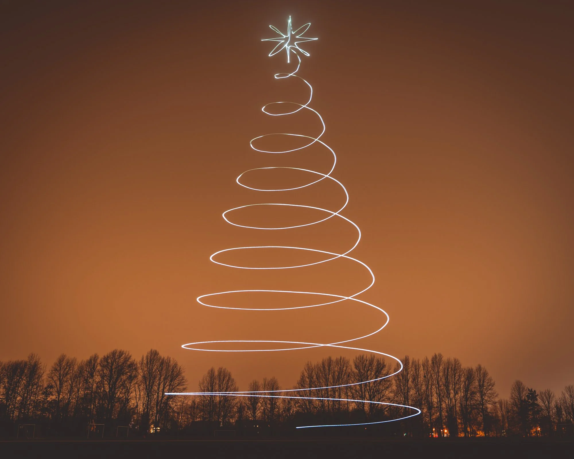
Drone light painting - Christmas Tree